
Scattered Severe Storms Possible This Evening
The National Weather Service says scattered strong to severe storms will be possible across southern Minnesota this evening.
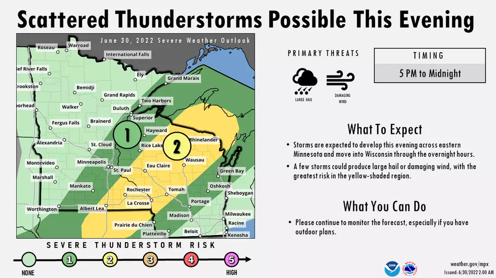
The primary risk from around 5 pm to 10 pm will be large hail, damaging wind, and heavy rain.

There will be isolated to scattered storms across the area through tonight. Some of these storms may be strong to severe between 5 PM and 10 PM. The primarily threats will be damaging winds and hail. Stay weather aware! Be ready to take shelter indoors when storms approach. Also, have multiple ways to receive warnings.
From the National Weather Service this morning: Scattered thunderstorms are expected to develop this evening and move east tonight. A few storms could produce damaging wind and large hail across eastern Minnesota and Wisconsin. Please continue to monitor the forecast, especially if you have outdoor plans.
What About the Fourth of July Weekend Forecast?
That's a little iffy to use a very technical term. Friday looks great, but there's a chance of thunderstorms Saturday, Sunday, and on Independence Day. It won't be a complete washout, and you should continue to plan your picnics, barbecues, and fireworks viewing -- but keep in mind that Mother Nature may throw a shower or storm into the mix each day.
- FRI 7/1: Sunny, with a high 81.
- SAT 7/2: Partly sunny with a 20% chance of afternoon thunderstorms, high 82.
- SUN 7/3: Mostly sunny, with a 20% chance of afternoon thunderstorms, high 85.
- MON 7/4: Mostly sunny, with a 40% chance of afternoon thunderstorms, high 85.
Final word from the NWS on your holiday weekend: Although precipitation chances increase by the 4th of July, uncertainties remain on how widespread or organized the precipitation becomes. Continue to plan for a mainly dry weekend, possibly an isolated thunderstorm, and seasonably mid-summer heat.
LOOK: The most extreme temperatures in the history of every state
Gallery Credit: Anuradha Varanasi
More From KQCL Power 96